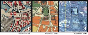
Memories of Old Urban Square of Surabaya
Do you know where Surabaya’s urban square or town square is? What are you thinking about the words “Surabaya’s town square”? Nowadays, the words town square is often used in the paradigm of shopping mall and department store, such as Surabaya’s town square, also the name of one of shopping mall in Surabaya and they said the mall has a concept design of town square. Is it truly town square? Where is the truly town square of Surabaya?
Indonesia has a long history of Alun-alun (bahasa Indonesia of town square). Alun-alun itself has already included in book of Negara Kertagama, hundred years ago. Long time a go, people believed that before they cultivated the land they had to make a worship to Goddess of land (dewi tanah) by making a wide sacred field in rectangular shape, here the story was beginning. In Kingdom Era, alun-alun was used to train soldiers, prize contests, royal word space, commercial space, and entertainment. Till now alun-alun is utilized as urban facilities such gathering space, society socialization, music concert, culture event, and so on. Alun-alun of Surabaya’s nowadays is Taman Surya, located in front of Surabaya’s Municipality Office, eastern section of Surabaya. But do people know where the location of old Alun-alun of Surabaya is?
Long before the city expanded to eastern section; center of activity of the city was located in surrounding Jembatan Merah (now this area is known as Old city of Surabaya). Around 1800s, a proposal was submitted to government to make green the urban space of Surabaya. The government approved and designed a city garden which was started from the corner of boeboetanweg (jalan bubutan) to regenstraat (jalan kebon rojo). The wide shady a city garden was surrounded by four streets, there were regenstraat (now jalan kebon rojo; according to the source reference there were a regent’s house in front of the alun-alun; but I do not know where it was the exact location), halteweg (the street has being closed), boeboetanweg (jalan bubutan), and passar besarweg or called aloen-aloenstraat as well (now jalan pahlawan). It also said that Mosque of Kemayoran was in the town square area before it moved to jalan Indrapura (present existing).
Always located in the center of activity of the city, the surrounding buildings of alun-alun have an important role to the city such as civic building, governments, official’s residence, and worship buildings. According to book of Soerabaia tempo doeloe which describe Surabaya in around 1910, in the northern alun-alun were a regent’s residence. While the corner of northwest alun-alun was drama and performing arts building called komedie. Mosque of Kemayoran also could be seen from the northwest alun-alun (the mosque already moved in jalan indrapura). Western alun-alun was a trade and commercial area, pasar turi. Along with the development of Surabaya, In order to appreciating and remembering the former heroes who had struggled to defend an independence of Republic of Indonesia, the government of Surabaya designed and built a monument of Tugu Pahlawan, and city garden beside the Alun-alun. By the year of 1990s the government added a museum into the complex of monument Tugu Pahlawan. And how is the alun-alun today? In around 1960s, in the location of alun-alun was built a building of Bank of Indonesia and old alun-alun was going to the vanishing point. There is no remaining of historic evidence of old alun-alun that we could observe. They only leave over the stories, memories, and nostalgias.
http://commons.wikimedia.org/wiki/Image:Peta_soerabaja_1897.jpg
Widodo, Dukut Imam. 2002. Soerabaia Tempo Doeloe chapter 2.
Map of Surabaya 1940, scanned from Soerabaja 1900-1950, Asia Maior.
White-Black Photographs, courtesy of Olivier Johannes.


Setyo, kamu sudah mendahului STD 🙂
mendahului apanya mas? kita sama-sama belajar kan..^^
maturnuwun kunjungannya.